Image
Document
Document
Document
NOTAMs
View NOTAMS and important notices
John Wayne Airport, Orange County (SNA)
| Location |
|---|
| 4 nm S of the City of Santa Ana |
| N33° 40.54’ W117° 52.09’ |
| On Los Angeles Sectional, L3-L4 and Terminal Area Charts |
| Distances from NAVAIDS: (• = DME) | ||||
|---|---|---|---|---|
| ELB | 117.2 | 255° | 7 nm | VOR only |
| SLI | 115.7• | 110° | 11 nm | VORTAC |
| PDZ | 112.2• | 215° | 22 nm | VORTAC |
| OCN | 115.3• | 303° | 34 nm | VORTAC |
| Distances from other airports: |
|---|
| 7 nm WSW of MCAS El Toro - CLOSED |
| 16 nm ESE of Long Beach |
| 12 nm SE of Fullerton |
| 19 nm SW of Corona |
| Communications Frequencies | ||
|---|---|---|
| Field Elevation: 56 feet MSL | ||
| ATIS | (714) 338-2340 | 126.00 |
| ASOS | (714) 338-2330 | |
| Clearance Delivery | ||
| VFR | 121.85 | |
| IFR | 118.00 | |
| John Wayne Ground* [Unless otherwise assigned by Tower] | ||
| ALL AIRCRAFT | 120.80 | |
| John Wayne Tower* [Operates: 0615 - 2300 LCL] | ||
| RWYs 20R/2L | 126.80 | |
| RWYs 20L/2R [RWY 20L/2R CLSD when Tower CLSD] | 119.90 | |
| Common Traffic Advisory Frequency (CTAF) | 126.80 | |
| SOCAL Approach Frequencies* | ||
| NE | 121.30 | |
| E/SE | 124.10 | |
| SW/NW | 125.35 | |
| All Jets | ||
| Approach | 121.30 | |
| Departure | 128.10 | |
| *[NOTE: Monitor ATIS prior to contacting Clearance Delivery, Ground, Tower, or Approach Control for frequencies in use.] | ||
| NORMAL VFR ARRIVAL ROUTES: | |
|---|---|
| Expected Arrival Clearances: | |
| Arriving: | (East) From El Toro proceed to Signal Peak |
| Expect: | Enter LEFT Traffic, RWY 20L; report UCI. |
| Arriving: | (SE) Dana Point and Laguna Beach |
| Expect: | Proceed to Signal Peak for LEFT Traffic, RWY 20L; report UCI. |
| Arriving: | (SW) Huntington Pier |
| Expect: | Cross over the control tower at or above 1300 for left downwind entry RWY 20L. |
| Arriving: | (W/NW) Mile Square Park |
| Expect: | Cross over the control tower at or above 1300 for left downwind entry RWY 20L. |
| MISC. APPROACH FREQUENCIES: | ||
|---|---|---|
| ILS Localizer/DME: | I-SNA | 111.75 |
| LDA Localizer/DME: | I-OJW | 108.30 |
| AFSS: | RAL | 122.45 |
| VOT: | 110.00 | |
| TRAFFIC PATTERN ALTITUDES: |
|---|
| Rwy 2L/20R TPA: |
| 1056 (1000) small aircraft, 1556 (1500) turbine aircraft over 12500 lbs. |
| Rwy 2R/20L TPA: |
| 856 (800) small single engine aircraft, 1056 (1500) twin engine aircraft. |
| NORMAL VFR DEPARTURE ROUTES: |
|---|
| Departing E/NE: El Toro Departure - "Fly heading 080° " |
| Departing SE: Newport Departure - "Fly heading 150° " |
| Departing SW: Mesa Departure - "Fly heading 220° " |
| Departing NW: Orange Departure - "Fly heading 340° " |
| Squawk Code, Advisory Frequency, and Altitude as assigned. |
| Pilots not requesting radar service beyond the surface area of the Class C airspace may state “local” when requesting their departure route. (Example: “John Wayne Clearance, Cessna N739MB, west-side parking, Mesa Local Departure.”) Local radar service will be terminated upon exiting the 5 nm surface area of the Class C airspace. Pilots must then remain clear of all other regulated airspace, including the upper tier of the Class C airspace. |
| AVOID OVERFLIGHT OF 20R/2L: |
|---|
| VFR aircraft: To avoid overflight of Rwy 20R/2L: |
| Rwy 20L arrival fly final at 15° angle to Rwy, Rwy 20L departures turn LEFT 15° at departure end of runway. |
| To avoid overflights of Rwy 2L, Rwy 2R departures turn RIGHT 15° at departure end of runway. |
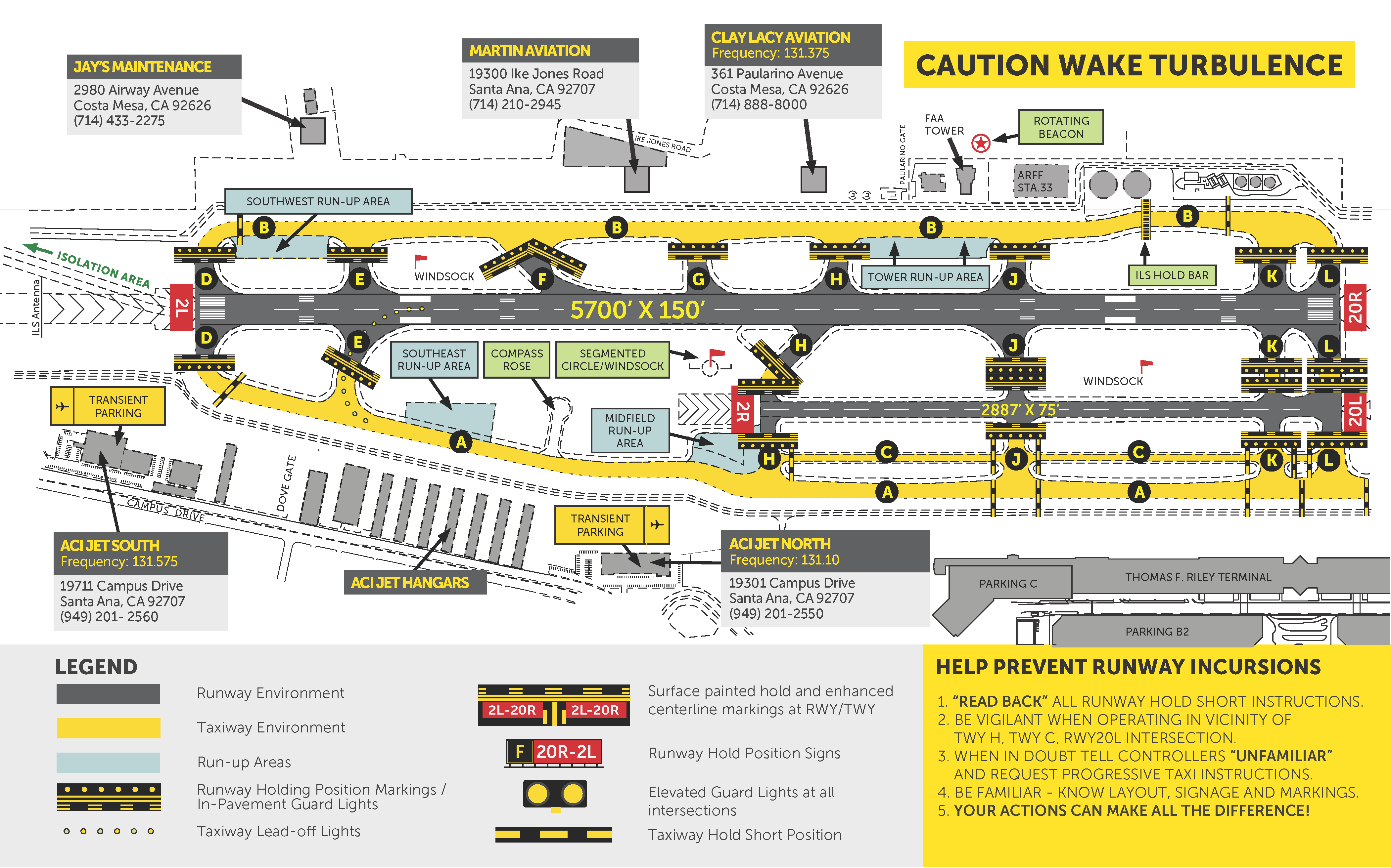
SNA Tenants
Fixed Base Operators
ACI Jet
19301 Campus Drive, Suite 100Santa Ana, CA, 92707Phone: (949) 201-2550Text Reservation Requests: (949) 344-2450Email: sna@acijet.comContact: Nathen SteigerFrequency: 131.10Clay Lacy Aviation
Website: https://www.claylacy.com/361 Paularino AvenueCosta Mesa, California 92626Phone: (714) 888-8000Email: SNACSR@claylacy.comContact: Scott CutshallFrequency: 131.375
View General Aviation Services listing...
Preventing Runway Incursions
- “Read back” all runway hold short instructions.
- Be vigilant when operating in vicinity of TWY H, TWY C, RWY20L intersection.
- When in doubt tell controllers “unfamiliar” and request progressive taxi instructions.
- Be familiar – know layout, signage and markings.
- Your actions can make all the difference!
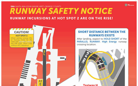
Runway Safety Notice
Image
Document
Resources
Gulfstream/Lear Noise Procedures
Document